


Environment
Latest Stories
8b04bb08b133550b4f0f6a70670017ff.jpg
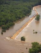
FILE - This June 18, 2008 aerial file photo shows a break in the Indian Grave levee caused by flood waters from the Mississippi River north of Quincy, Ill. A rate-relief law signed Friday, March 21, 2014 by President Barack Obama will soften the blow for those who were hit hardest by rate changes in the National Flood Insurance Program. An Associated Press analysis shows that half of the nearly 49,000 Illinois policies through the program are paying subsidized rates set to rise as those discounts are shaved or eliminated. The fallout appears profound in Illinois, partly because of the state's proximity to the Mississippi, Ohio and Illinois rivers and their tributaries. (AP Photo/Paul Beaty, File)
87c31ca3b133550b4f0f6a7067006a47.jpg
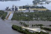
FILE - In this June 19, 2008 file photo, floodwaters from the Mississippi River surround a grain elevator in Meyer, Ill. after a levee failed, flooding the farming community. Policyholders who have long enjoyed subsidized rates under the debt-ridden National Flood Insurance Program will see premiums rise steadily in the coming years, despite a rate-relief law signed Friday, March 21, 2014 by President Barack Obama that will soften the blow for those who were hit hardest. The fallout appears profound in Illinois, partly because of the state's proximity to the Mississippi, Ohio and Illinois rivers and their tributaries. (AP Photo/M. Spencer Green, File)
cae47d6db137550b4f0f6a7067000bb6.jpg
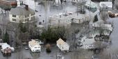
FILE - In this March 31, 2010 file photo, water encircles homes from the flooded Pawtuxet River in West Warwick, R.I. In 2012, Congress passed a law requiring approximately 1.1 million policyholders nationwide to start paying rates based on the true risk of flooding. Nearly 7,000 Rhode Island homeowners and businesses could see their flood insurance premiums rise annually by double digit percentages as government-backed insurance subsidies are scaled back, according to an Associated Press analysis of data from the National Flood Insurance Program. (AP Photo/Charles Krupa, File)

aac7583db134550b4f0f6a7067001ab6.jpg
Katherine and Robert Calhoun stand on a bridge overlooking Ecorse Creek behind their Dearborn Heights, Mich., home on Thursday, March 20, 2014. Living so close to the creek in a flood plain has been costly — not the least because it's flooded twice and once caused $19,000 worth of damage they had to pay after their insurance claim was rejected. When the Calhouns bought the house 22 years ago, they paid $300 annually for flood insurance. That bill is now $800. It will only get worse for the Calhouns and people around the nation when federal flood insurance premiums go up soon as decades-old subsides through the National Flood Insurance Program start to end. (AP Photo/Corey Williams)

eeceaf92b139550b4f0f6a7067000296.jpg
Kelley McClurkin, talks about how rising flood insurance costs will impact her bakery and deli in Findlay, Ohio on Thursday, March 20, 2014. Her bakery, which sits near a creek that flows into the Blanchard River, has been surrounded by water several times but flooded just once - in 2007 when the worst flooding in nearly a century left behind $100 million in damage. It ruined McClurkin's ovens, display cabinets and walk-in coolers. (AP Photo/John Seewer)
52612f7cb132550b4f0f6a706700c3ef.jpg
In this Oct. 31, 2012 aerial photo, a New York Air National Guard helicopter with Gov. Andrew Cuomo aboard flies over the ocean side community of Breezy Point in the Queens borough of New York to survey the damage caused by Superstorm Sandy. While President Barack Obama signed a law Friday, March 21, 2014 that will delay steep increases to flood insurance paid by many, nearly 60,000 policyholders in New York state are among the 1.1 million nationwide who will see their federally subsidized flood insurance premiums rise as part of changes to the National Flood Insurance Program, according to a review of federal data by The Associated Press. (AP Photo/Mark Lennihan)

9718d70fb20f590b4f0f6a706700fcff.jpg
A Japan Maritime Self-Defense Force P-3C Orion takes off from the Royal Australian Air Force Pearce Base to commence a search for possible debris from the missing Malaysia Airlines flight MH370, in Perth, Australia, Monday, March 24, 2014. Satellite images released by Australia and China had earlier identified possible debris in an area that may be linked to the disappearance of the flight on March 8 with 239 people aboard. (AP Photo/Paul Kane, Pool)

ca4827d0b213590b4f0f6a706700ec04.jpg
Japan Maritime Self-Defense Force farewell their P-3C Orion as it taxis from the Royal Australian Air Force Pearce Base to commence a search for possible debris from the missing Malaysia Airlines flight MH370, in Perth, Australia, Monday, March 24, 2014. Satellite images released by Australia and China had earlier identified possible debris in an area that may be linked to the disappearance of the flight on March 8 with 239 people aboard. (AP Photo/Paul Kane, Pool)

cefbdad3b1c2570b4f0f6a706700d40e.jpg
A Malaysian Chinese woman takes pictures of a message board for the missing Malaysia Airline, Flight MH370 with a mobile phone camera at a shopping mall in Kuala Lumpur, Malaysia, Monday, March 24, 2014. A Chinese plane on Monday spotted two white, square-shaped objects in an area identified by satellite imagery as containing possible debris from the missing Malaysian airliner, while the United States separately prepared to send a specialized device that can locate black boxes. (AP Photo/Joshua Paul)

410efaadb138550b4f0f6a7067008b04.jpg
FILE - In this Nov. 2, 1991 file photo, the driveway leading to U.S. President George H.W. Bush's vacation compound on Walker's Point in Kennebunkport, Maine is littered with rocks and rubble left by 20-foot waves from an Atlantic storm that damaged homes and flooded roads along the coast the previous week. In 2012, Congress passed a law requiring approximately 1.1 million policyholders nationwide to start paying rates based on the true risk of flooding. Thousands of Maine homeowners and businesses could see their flood insurance rise in an attempt to put the troubled National Flood Insurance Program back on sound financial footing. Bush's home is among the properties in the program. (AP Photo/Scott Perry, File)

bb31f76fb136550b4f0f6a70670032b2.jpg
Mitch Haddad stands on a second story balcony that overlooks marshlands and the harbor beyond at his restaurant, Haddad's Ocean Cafe, in the Brant Rock area of Marshfield, Mass., Friday, March 21, 2014. The restaurant has been in his family for over 70 years. When they decided to build a larger building recently, FEMA said the structure must be at least 11 feet off the ground. So they decided to go higher, building at 13 feet. About a year after the new restaurant opened, Mitch Haddad said they were told new federal flood maps now put the safe elevation at 16 feet. (AP Photo/Stephan Savoia)

be56eacbb136550b4f0f6a706700d7e1.jpg
Mitch Haddad, right, talks with a patron outside his restaurant, Haddad's Ocean Cafe, after lunch in the Brant Rock area of Marshfield, Mass., Friday, March 21, 2014. The restaurant has been in his family for over 70 years. When they decided to build a larger building recently, FEMA said the structure must be at least 11 feet off the ground. So they decided to go higher, building at 13 feet. About a year after the new restaurant opened, Mitch Haddad said they were told new federal flood maps now put the safe elevation at 16 feet. (AP Photo/Stephan Savoia)

74f2692ab13e550b4f0f6a7067008374.jpg
Realtor Bob Preston stands for a photograph looking towards the ocean on his property in Hampton, N.H. on Friday, March 21, 2014. Preston says he has lived on New Hampshire’s seacoast his entire life and his family has sold and rented properties there for decades. He’s never had a property flood but still pays for federally mandated flood insurance. Like thousands of others across New Hampshire whose flood insurance is subsidized by the government, the amount he pays is about to go up because of changes to the National Flood Insurance Program. (AP Photo/Jim Cole)