


Environment
Latest Stories

a5efba9fb37f600b4f0f6a7067004526.jpg
Medical personnel and people use a stretcher to carry out a woman who fainted after the announcement by the Malaysian government that the missing Malaysia Airlines airliner MH370 had crashed in the Indian Ocean, from a hotel ballroom in Beijing, China Monday, March 24, 2014. It was the grim news that families of the missing Malaysian Airlines flight had dreaded for weeks, and on Monday they heard it from Malaysia’s prime minister: new analysis of satellite data indicates the missing plane crashed into a remote corner of the Indian Ocean. (AP Photo) CHINA OUT

83799632b3725f0b4f0f6a7067000c41.jpg
Malaysian Prime Minister Najib Razak speaks during a press conference for the missing Malaysia Airlines, flight MH370, in Kuala Lumpur, Malaysia, Monday, March 24, 2014. A new analysis of satellite data indicates the missing Malaysia Airlines plane crashed into a remote corner of the Indian Ocean, Najib said Monday. (AP Photo/Joshua Paul)
98d31890b4b9650b4f0f6a706700ddb3.jpg
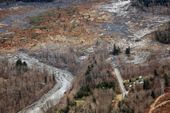
This March 22, 2014 photo, made available by the Washington State Dept of Transportation shows a view of the damage from Saturday's mudslide in Oso, Wash. At least eight people were killed in the 1-square-mile slide that hit in a rural area about 55 miles northeast of Seattle on Saturday. Several people also were critically injured, and about 30 homes were destroyed. (AP Photo/Washington State Dept of Transportation)

f1142cbb8eab440b4f0f6a7067006592.jpg
FILE - This Wednesday Feb. 5, 2014 file photo shows state and federal officials dock after collecting sediment samples as coal ash surfaces on the water on the Dan River in Danville, Va. A coal ash spill from a break in a 48-inch storm water pipe at the Dan River Power Plant in Eden N.C. on Sunday released up to 82,000 tons of ash according to Duke Energy. (AP Photo/Gerry Broome)
22617f03b46f640b4f0f6a7067001ea0.jpg
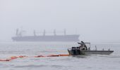
A boat drags an oil boom out into the water as a cargo ship sits in the ship waits to enter the ship channel along East Beach Monday, March 24, 2014, in Galveston, Texas. The booms are being placed along the coastline to help clean up the thousands of gallons of tar-like oil spilled into the major U.S. shipping channel after a barge ran into a ship Saturday. (AP Photo/Pat Sullivan)
5e1433f0b481640b4f0f6a7067006779.jpg
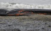
A boom and the sand along East Beach are covered in oil Monday, March 24, 2014, in Galveston, Texas. Thousands of gallons of tar-like oil spilled into the major U.S. shipping channel after a barge ran into a ship Saturday. (AP Photo/Pat Sullivan)
e758b72ab46f640b4f0f6a706700291e.jpg
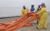
An oil spill clean up crew drags a boom along East Beach in Galveston, Texas, Monday, March 24, 2014. Thousands of gallons of tar-like oil spilled into the major U.S. shipping channel after a barge ran into a ship Saturday. (AP Photo/Pat Sullivan)

Clint_Eastwood2
Actor, film director and producer Clint Eastwood served as the nonpartisan mayor of Carmel-by-the-Sea, California from 1986 to 1988.
1985ba9bb403620b4f0f6a7067009d37.jpg
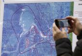
A news person photographs a map showing the location of a deadly mudslide that happened two days earlier, before a news conference, Monday, March 24, 2014, in Arlington, Wash. Officials said that there are currently 108 names of people who have been reported missing or are unaccounted for from the Saturday morning slide, but cautioned the figure would likely decline dramatically. Eight people are so far confirmed dead from the one-square mile slide that destroyed about 30 homes and critically injured several people. (AP Photo/Elaine Thompson)

6671aa68b402620b4f0f6a7067002094.jpg
Snohomish County Fire District 21/22 Chief Travis Hot speaks during a news conference about a deadly mudslide that happened two days earlier, Monday, March 24, 2014, in Arlington, Wash. Officials said that there are currently 108 names of people who have been reported missing or are unaccounted for from the Saturday morning slide, but cautioned the figure would likely decline dramatically. Eight people are so far confirmed dead from the one-square mile slide that destroyed about 30 homes and critically injured several people. (AP Photo/Elaine Thompson)

f95af599b3e6610b4f0f6a706700d32b.jpg
Allen Johnson, center, Arlington City Manager, stands with city council member Jan Schuette, left, and former council member Linda Byrnes after listening in on a news conference about a deadly mudslide Monday, March 24, 2014, in Arlington, Wash. The search for survivors of the deadly mudslide grew Monday to include 108 names of people who were reported missing or were unaccounted for, but authorities cautioned the figure would likely decline dramatically. The size of the list raised concerns the death toll would rise far above the eight people who have been confirmed dead after the 1-square-mile (2.6-square-kilometer) slide Saturday swept through part of a former fishing village about 55 miles (80 miles) northeast of Seattle. Several people also were critically injured. About 30 homes were destroyed, and the debris blocked a 1-mile (1.6 kilometer) stretch of state highway. (AP Photo/Elaine Thompson)

1463b92bb2bf5c0b4f0f6a706700e79c.jpg
A ground controller guides a Royal Australian Air Force AP-3C Orion to rest after sunset upon its return from a search for the missing Malaysia Airlines flight MH370 over the Indian Ocean, at the Royal Australian Air Force base Pearce, near Perth March 24, 2014. Satellite images released by Australia and China had earlier identified possible debris in an area that may be linked to the disappearance of the flight on March 8 with 239 people aboard. (AP Photo/Jason Reed, Pool)