


Environment
Latest Stories
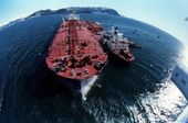
4e27c6756ae02d0b4f0f6a706700500a.jpg
In this April 4, 1989, file photo, the grounded tanker Exxon Valdez, left, unloads oil onto a smaller tanker, San Francisco, as efforts to re-float the ship continue on Prince William Sound, 25 miles from Valdez, Alaska. The 987-foot tanker, carrying 53 million gallons of crude, struck Bligh Reef at 12:04 a.m. on March 24, 1989, and within hours unleashed an estimated 10.8 million gallons of thick, toxic crude oil into the water. Storms and currents then smeared it over 1,300 miles of shoreline. Twenty five years later, the region, its people and its wildfire are still recovering. (AP Photo, File) **FILE**
aed57f256ae02d0b4f0f6a7067002a24.jpg
FILE - In this April 16, 1989, file photo, a clean-up worker rakes through crude oil, contained by floating booms off the waters of Prince William Sound, Alaska. The oil, contained here in Snug Harbor off Knight Island, was later sucked off the water by a U.S. Coast Guard skimmer. Oil from the tanker Exxon Valdez continues to foul the waters of southern Alaska. Nearly 25 years after the Exxon Valdez oil spill off the coast of Alaska, some damage heals, some effects linger in Prince William Sound. (AP Photo/John Gaps III, File)

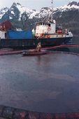
bae0a90b6ae02d0b4f0f6a7067007cf8.jpg
FILE - In this April 17, 1989, file photo, a worker makes his way across the polluted shore of Block Island, Alaska, as efforts are underway to test techniques to clean up the oil spill of the tanker Exxon Valdez in Prince William Sound. The worker periodically uses the bucket to scoop up oil washing back onto shore from the containment booms. Nearly 25 years after the Exxon Valdez oil spill off the coast of Alaska, some damage heals, some effects linger in Prince William Sound. (AP Photo/John Gaps III, File)

1962b4796ae12d0b4f0f6a7067005a8b.jpg
FILE - In this April 18, 1989 file photo, a rescued sea otter is restrained and washed by workers at a local animal facility after five of the oil covered mammals were captured in the fouled waters of Prince William Sound, Alaska. The list of animals injured and killed from the spill of the oil tanker Exxon Valdez includes sea otters, deer, eagles, owls and a host of other water fowl gathered up by rescue workers. Nearly 25 years after the Exxon Valdez oil spill off the coast of Alaska, some damage heals, some effects linger in Prince William Sound. (AP Photo/John Gaps III, File)
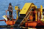
4d2833a96ae12d0b4f0f6a7067006038.jpg
FILE - In this April 21, 1989, file photo, a skimmer is used for shoreline oil in Naked Island, Alaska. It collects the oil from off the water surface. The conveyor belt moves the oil onto a barge for storage. Nearly 25 years after the Exxon Valdez oil spill off the coast of Alaska, some damage heals, some effects linger in Prince William Sound. (AP Photo/Rob Stapleton, File)