


Environment
Latest Stories

WTC.jpg
Sea water floods the Ground Zero construction site, Monday, Oct. 29, 2012, in New York. Sandy continued on its path Monday, as the storm forced the shutdown of mass transit, schools and financial markets, sending coastal residents fleeing, and threatening a dangerous mix of high winds and soaking rain. (AP Photo/ John Minchillo)

Superstorm Sandy_Star.jpg
Lower Manhattan goes dark during hurricane Sandy, on Monday, Oct. 29, 2012, as seen from Brooklyn, N.Y. Sandy continued on its path Monday, as the storm forced the shutdown of mass transit, schools and financial markets, sending coastal residents fleeing, and threatening a dangerous mix of high winds and soaking rain. (AP Photo/Bebeto Matthews)

STORM_20121029_0330
Members of the Merino family carry belongings to waiting cars as they leave their home on Arlington Terrace in the Huntington neighborhood of Alexandria, Va., on Oct. 29, 2012, during a mandatory evacuation order as high winds and heavy rain from Hurricane Sandy pound the Atlantic coast. (Rod Lamkey Jr./The Washington Times)

STORM_20121029_0298
Members of the Merino family carry belongings to waiting cars as they leave their home on Arlington Terrace in the Huntington neighborhood of Alexandria, Va., on Oct. 29, 2012, during a mandatory evacuation order as high winds and heavy rain from Hurricane Sandy pound the Atlantic coast. (Rod Lamkey Jr./The Washington Times)

TV.jpg
Rick Knabb, director of the National Hurricane Center, points to the satellite image of hurricane Sandy at the National Hurricane Center in Miami, Monday, Oct. 29, 2012. (AP Photo/Alan Diaz)

SUPERSTORM_SANDY2102953
Michael Wirtz, of Wilmington, Del., braves flood waters and high winds that arrive with Hurricane Sandy along North Michigan Avenue in Atlantic City, N.J., Monday Oct. 29, 2012. Hurricane Sandy continued on its path Monday, forcing the shutdown of mass transit, schools and financial markets, sending coastal residents fleeing for higher ground, and threatening a dangerous mix of high winds and soaking rain. (AP Photo/The Press of Atlantic City, Michael Ein) MANDATORY CREDIT

SUPERSTORM_SANDY2102952
New Bedford, Mass., firefighters survey damage caused when high winds generated by Hurricane Sandy toppled a chimney through a skylight and into the kitchen of an apartment in New Bedford Monday, Oct. 29, 2012. The apartments were evacuated, and no one was injured. (AP Photo/The Standard-Times, Peter Pereira)

SUPERSTORM_SANDY2102949
A downed limb lies in a flooded street as Hurricane Sandy approaches, Monday, Oct. 29, 2012, in Center Moriches, N.Y. (AP Photo/Jason DeCrow)

SUPERSTORM_SANDY2102948
U.S. Fuel gas station store manager Tsewang Guyrme, of Phillipsburg, N.J., wraps one of his newly installed Mobil gas tanks with bubble and shrink wrap, Monday, Oct. 29, 2012, to protect them from possible flying debris in Phillipsburg. His station on Memorial Parkway is converting to a Mobil gas station. Hurricane Sandy continued on its path Monday, forcing the shutdown of mass transit, schools and financial markets, sending coastal residents fleeing for higher ground, and threatening a dangerous mix of high winds and soaking rain. (AP Photo/The Express-Times, Lisa Massey)

SUPERSTORM_SANDY2102941
Rising water from the Hudson River overtakes a bank drive through in Edgewater, N.J., Monday, Oct. 29, 2012 as Hurricane Sandy lashed the East Coast. In the background is the historic ferry boat named the Binghamton, swamped by the waves. Hurricane Sandy continued on its path Monday, as the storm forced the shutdown of mass transit, schools and financial markets, sending coastal residents fleeing, and threatening a dangerous mix of high winds and soaking rain. (AP Photo/Craig Ruttle)

SUPERSTORM_SANDY2102939
A sign informs motorists along U.S. Route 50 that Maryland's Chesapeake Bay Bridge, which connects the state's eastern and western shores, is closed because of winds from Hurricane Sandy Monday, Oct. 29, 2012. (AP Photo/Steve Ruark)
SUPERSTORM_SANDY2102938
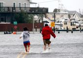
People run through a flooded street as Hurricane Sandy approaches, Monday, Oct. 29, 2012, in Lindenhurst, N.Y. Hurricane Sandy continued on its path Monday, as the storm forced the shutdown of mass transit, schools and financial markets, sending coastal residents fleeing, and threatening a dangerous mix of high winds and soaking rain. (AP Photo/Jason DeCrow)

SUPERSTORM_SANDY2102937
People brace against a gust from Hurricane Sandy in Brooklyn's Dumbo neighborhood Monday, Oct. 29, 2012, in New York. Residents of the neighborhood were ordered to evacuate because of the storm surge expected from the hurricane. Authorities warned that New York City and Long Island could get the worst of the storm surge: an 11-foot onslaught of seawater that could swamp lower areas of the city. (AP Photo/Bebeto Matthews)

SUPERSTORM_SANDY2102936
Homeowner Raymond Gara, left, and another man looks on as a tree sits on his house on Raubsville Road after strong storm winds brought on by Hurricane Sandy took it down, Monday, Oct. 29, 2012, in Williams Township, Pa. (AP Photo/The Express-Times, Matt Smith)

SUPERSTORM_SANDY2102935
An abandoned beach house that survived the storm surge from Hurricane Sandy sits off center in Nags Head, N.C., Monday, Oct. 29, 2012. The storm continued on its path Monday, forcing the shutdown of mass transit, schools and financial markets, and sending coastal residents fleeing. (AP Photo/Gerry Broome)

SUPERSTORM_SANDY2102930
Toll lanes are closed at Maryland's Chesapeake Bay Bridge, which is closed because of winds from Hurricane Sandy, Monday, Oct. 29, 2012. Hurricane Sandy continued on its path Monday, as the storm forced the shutdown of mass transit, schools and financial markets, sending coastal residents fleeing, and threatening a dangerous mix of high winds and soaking rain. (AP Photo/Steve Ruark)

SUPERSTORM_SANDY2102928
Flooding and high winds arrive along North Michigan Avenue in Atlantic City, N.J., Monday Oct. 29, 2012. Hurricane Sandy continued on its path Monday, as the storm forced the shutdown of mass transit, schools and financial markets, sending coastal residents fleeing, and threatening a dangerous mix of high winds and soaking rain. (AP Photo/The Press of Atlantic City, Michael Ein)