


Weather
Latest Stories

SANDYNATION_102814
Passengers wait for their flight at at LaGuardia airport, Sunday, Oct. 28, 2012 in New York. Tens of thousands of residents were ordered to evacuate coastal areas Sunday as big cities and small towns across the Northeast buttoned up against the onslaught of a superstorm (AP Photo/Mary Altaffer)

SANDYNATION_102811
Residents still hang around the Rehoboth boardwalk as businesses board up their windows in preparation for the approaching Hurricane Sandy. (AP Photo/The News Journal, Suchat Pederson)

SANDYNATION_102810
A car goes through the high water as Hurricane Sandy bears down on the East Coast, Sunday, Oct. 28, 2012, in Ocean City, Md. Governors from North Carolina, where steady rains were whipped by gusting winds Saturday night, to Connecticut declared states of emergency. (AP Photo/Alex Brandon)

SANDYNATION_102809
Tom Morehead, a driver with Ocean City, Md., public transportation, assists Evelyn Krainatc to a convention center on her way to a shelter, as Hurricane Sandy bears down on the East Coast, Sunday, Oct. 28, 2012, in Ocean City, Md. Tens of thousands of people were ordered to evacuate coastal areas Sunday as big cities and small towns across the U.S. Northeast braced for the onslaught of a superstorm threatening some 60 million people along the most heavily populated corridor in the nation. (AP Photo/Alex Brandon)

SANDYNATION_102808
Rehoboth Beach, Del., business owners Darryl Ciarlante, left, and Joe Zuber, center, board their windows as Hurricane Sandy approaches the area. (AP Photo/The News Journal, Suchat Pederson)

SANDYNATION_102807
Mike Strobel fills sand bags for his business, Mike's Carpet Connection, as Hurricane Sandy bears down on the East Coast, Sunday, Oct. 28, 2012, in Fenwick Island, Del. (AP Photo/Alex Brandon)
SANDYNATION_102806
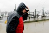
Skip Horney shields himself from the blowing rain after helping secure boats at Broad Creek Marina in Wanchese, N.C., Sunday, Oct. 28, 2012, as Hurricane Sandy moves up the East Coast. (AP Photo/Gerry Broome)

SANDYNATION_102805
High winds blow sea foam into the air as a person walks across Jeanette's Pier in Nags Head, N.C., Sunday, Oct. 28, 2012, as wind and rain from Hurricane Sandy move into the area. Governors from North Carolina, where steady rains were whipped by gusting winds Saturday night, to Connecticut declared states of emergency. (AP Photo/Gerry Broome)

SANDYNATION_102804
Ocean water rolls over NC 12 at the north end of Buxton, N.C. at dawn on Sunday, Oct. 28, 2012. Waves from offshore Hurricane Sandy are battering Hatteras Island. (AP Photo/The Virginian-Pilot, Steve Earley)

SANDYNATION_102803
A police officer sets up a road block on South Oregon Inlet Road as water from Hurricane Sandy covers the road in Nags Head, N.C. (AP Photo/Gerry Broome)

SANDYNATION_102802
A news crew wades through sea foam blown onto Jeanette's Pier in Nags Head, N.C., Sunday, Oct. 28, 2012 as wind and rain from Hurricane Sandy move into the area. Governors from North Carolina, where steady rains were whipped by gusting winds Saturday night, to Connecticut declared states of emergency. Delaware ordered mandatory evacuations for coastal communities by 8 p.m. Sunday. (AP Photo/Gerry Broome)

SANDYNATION_102801
A maintenance worker named Vitto attaches plywood to a sidewalk grate at the 2 Broadway building of Lower Manhattan in New York, Sunday, Oct. 28, 2012, as a child walking by takes advantage of the temporary structure. Areas along the Northeast Coast are preparing for the arrival of Hurricane Sandy and a possible flooding storm surge. (AP Photo/Craig Ruttle)

STORM_102814
A stuffed "Jason" replica from the Friday the 13th movies sits on a bench next to a stack of sandbags that line the stairway to a basement apartment in the Bloomingdale neighborhood off of Rhode Island Avenue in Washington, D.C. on Sunday, Oct. 28, 2012. D.C. residents in this neighborhood are particularly concerned about flooding issues from Sandy, the so-called "Frankenstorm," which is expected to hit the area sometime tonight. (Barbara L. Salisbury/The Washington Times)

STORM_102810
Department of Public Works employee Bobby White, left, hands Norman Wood a sandbag to place into a District resident's car outside of Coolidge High School in Washington, D.C. on Sunday, Oct. 28, 2012. Residents waited in long lines for their allotted five sandbags to try to protect against flooding from Hurricane Sandy, the so-called "Frankenstorm" that is going to hit the Washington, D.C. metropolitan area. (Barbara L. Salisbury/The Washington Times)

STORM_102809
A long line of cars waits outside of Coolidge High School in Washington, D.C. to pick up sandbags from the Department of Public Works on Sunday, Oct. 28, 2012 in anticipation of high water levels from large amounts of rain due to Hurricane Sandy. (Barbara L. Salisbury/The Washington Times)

STORM_102804
Fire Chief Kenneth Ellerbe said that if winds are 40 mph, first-responder vehicles, particularly ambulances, will not be able to safely travel on the roads. Currently there are hurricane-force winds, upwards of 75 mph, where the storm has hit in the Chesapeake region. (Barbara L. Salisbury/The Washington Times)

STORM_102801
Sandbags sit outside the doorway and outdoor chairs and tables have been moved into an alcove of a business along Rhode Island Avenue in Washington, D.C. on Sunday, Oct. 28, 2012 in anticipation of high water levels from Sandy, the super storm that is expected to hit the area Sunday night or early Monday morning. (Barbara L. Salisbury/The Washington Times)

gray.jpg
Mayor Vincent Gray and local safety officials held a press conference Sunday, Oct. 28, 2012 at the headquarters of the D.C. Homeland Security and Emergency Management Agency to announce preparations for Sandy, the so-called "Frankenstorm" that is due to affect the Washington, D.C. metro area, with hurricane-force winds as early as 8 a.m. Monday morning. The mayor announced that D.C. Public Schools would be closed on Monday. Fairfax and Prince George's counties have also closed schools in anticipation of the storm. (Barbara L. Salisbury/The Washington Times)

APTOPIX Superstorm_Lea(1).jpg
Matt Francis of Virginia Beach holds on to his hat as the wind-driven sand and rain from Hurricane Sandy blow across the beaches of Sandbridge in Virginia Beach on Sunday, Oct. 28, 2012. (L. Todd Spencer/The Virginian-Pilot)