


Environment
Latest Stories
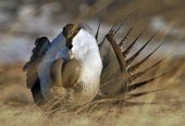
132538e2768f38084d0f6a7067000551.jpg
FILE --In this April 15, 2008 file photo, a male sage grouse performs his "strut" near Rawlins, Wyo. Divisions in Nevada’s approach to sage grouse have resurfaced in the state’s fragile attempt to keep the bird off the list of endangered species and avoid economic consequences for ranching, mining and alternative energy development across large swaths of the state.(AP Photo/Rawlins Daily Times, Jerret Raffety, File)

b19884dc761936084d0f6a706700427d.jpg
The headquarters of the South Carolina Department of Health and Environmental Control, or DHEC, in Columbia., S.C. is seen on Thursday, Feb. 27, 2014. The South Carolina Supreme Court will hear arguments on March 6, 2014 over whether the agency can end a program regulating the building or expansion of medical facilities in the state. The agency suspended the Certificate of Need program last year after Gov. Nikki Haley vetoed $1.7 million needed to run the program. (AP Photo/Bruce Smith)

152e629f761a36084d0f6a706700f712.jpg
The headquarters of the South Carolina Department of Health and Environmental Control, or DHEC, in Columbia., S.C. is seen on Thursday, Feb. 27, 2014. The South Carolina Supreme Court will hear arguments on March 6, 2014 over whether the agency can end a program regulating the building or expansion of medical facilities in the state. The agency suspended the Certificate of Need program last year after Gov. Nikki Haley vetoed $1.7 million needed to run the program. (AP Photo/Bruce Smith)

ad9b8cf2765837084d0f6a7067000b2f.jpg
In this Wednesday, Feb. 12, 2014 photo, Connie Custer makes kissing sounds that parrot Frank responds to at the Bird Nerds Rescue and Sanctuary in Canton, Ohio. Frank, a green Quaker, plucked himself because of neglect and a poor diet. The feathers, pulled out at the follicle, will not grow back on his bare, goose-bump skin. Custer said the average bird is re-homed as many as two to eight times in its life. Bird Nerds has attempted to end that cycle by housing and caring for neglected, unwanted and abused parrots. (AP Photo/The Repository, Stan Myers)
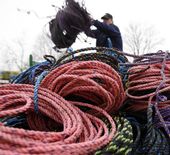
f6331e9c763637084d0f6a706700384b.jpg
FILE - In this March 27, 2009 file photo, a lobsterman throws additional fishing rope onto a pile in Rockland, Maine. Researcher Scott Kraus said at the annual Maine Fishermen's Forum in February 2014 in Rockland, that preventing endangered North Atlantic right whales from becoming entangled in lobster gear could be as simple as changing the color of the rope. (AP Photo/Pat Wellenbach, File)

60d095c1731428084d0f6a7067005f48.jpg
FILE - In this March 6, 2013 file photo, a warning sign is shown attached to a fence at the 'C' Tank Farm at the Hanford Nuclear Reservation, near Richland, Wash. Documents obtained by the Associated Press show that there are “significant construction flaws” in some newer, double-walled storage tanks at the nuclear waste complex. (AP Photo/Ted S. Warren, File)

35b3660f731528084d0f6a7067005b90.jpg
FILE - In this June 19, 2013 file photo, U.S. Energy Secretary Ernest Moniz, center left, answers questions from reporters in Richland, Wash., before touring the Hanford Nuclear Reservation. Documents obtained by the Associated Press show that there are “significant construction flaws” in some newer, double-walled storage tanks at the nuclear waste complex and in a letter Moniz, Friday, Feb. 28, 2014, Sen. Ron Wyden, D-Ore., called for better management of Hanford by the Dept. of Energy. (AP Photo/The Tri-City Herald, Kai-Huei Yau, file) LOCAL TV OUT; LOCAL RADIO OUT KONA
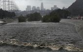
59631bb5733829084d0f6a7067002273.jpg
With the Los Angeles skyline in the background, the Los Angeles River flows Friday, Feb. 28, 2014. Two men and their dogs were rescued earlier from the swift waters of the Los Angeles River. A few miles downriver, another man was pulled out and carried to safety. Even with rainfall totals exceeding six inches in some places Friday, the powerful Pacific storm did not put a major dent in a drought that is among the worst in recent California history. (AP Photo/Damian Dovarganes)
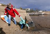
0d140583737a2a084d0f6a7067007ef1.jpg
Meredith McCarthy and her son Jasper Ward, 7, retrieve a plastic bottle as volunteers with Heal The Bay's storm response team remove snack-food packaging, plastic drink containers, single-use bags and other debris washed into the ocean from the Pico-Kenter outfall, a storm drain that serves a large part of the Westside of Los Angeles, at Santa Monica Beach, Friday, Feb. 28, 2014. Heavy rains will flush accumulated trash into the ocean, where it becomes a health hazard to humans and sea life. (AP Photo/Reed Saxon)
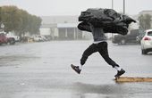
2c580d2973c32b084d0f6a706700bad6.jpg
Manufacturing Assembly worker Terry Young, 24, of Rialto, Calif., uses a sheet of plastic to protect himself from a downpour Friday, Feb. 28, 2014, as he jumps a flooded parking lot from a wood pallet to get to a food truck during his break in Anaheim, Calif. The first wave of a powerful Pacific storm spread rain and snow early Friday through much of California, where communities endangered by a wildfire just weeks ago now faced the threat of mud and debris flows. (AP Photo/The Orange County Register, Ken Steinhardt) MAGS OUT; LOS ANGELES TIMES OUT