


Environment
Latest Stories
4423841c6773d60c4f0f6a7067000477.jpg
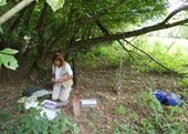
In this photo taken July 18, 2008, and provided by the U.S. Geological Survey, Lindsay Shirk, at the time a student at Delaware Valley College, collects soil in Wyoming. The federal government sent students and scientists to more than 4,800 places across the nation to collect soil that was analyzed for its composition. The results are now highly sought after by researchers in a wide variety of fields. (AP Photo/U.S. Geological Survey)
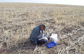
eca662476776d60c4f0f6a706700b789.jpg
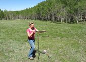
In this photo taken June 2, 2010, and provided by the U.S. Geological Survey, Jazelle Mondeau, at the time a student at University of Arizona, collects soil in the Texas Panhandle. The federal government sent students and scientists to more than 4,800 places across the nation to collect soil that was analyzed for its composition. The results are now highly sought after by researchers in a wide variety of fields. (AP Photo/U.S. Geological Survey)
2838e95d6777d60c4f0f6a706700c5bb.jpg
In this photo taken June 1, 2010, and provided by the U.S. Geological Survey, Joseph Daniel, at the time a student at North Carolina State University, collects soil in Southern California. The federal government sent students and scientists to more than 4,800 places across the nation to collect soil that was analyzed for its composition. The results are now highly sought after by researchers in a wide variety of fields. (AP Photo/U.S. Geological Survey)
62d0554d6777d60c4f0f6a706700969e.jpg
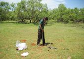
In this photo taken Sept. 11, 2008, and provided by the U.S. Geological Survey, geologist Helen Folger of the U.S. Geological Survey collects soil in West Virginia. The federal government sent students and scientists to more than 4,800 places across the nation to collect soil that was analyzed for its composition. The results are now highly sought after by researchers in a wide variety of fields. (AP Photo/U.S. Geological Survey)
a0028ff46777d60c4f0f6a7067003f2b.jpg
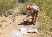
In this photo taken April 16, 2008, and provided by the U.S. Geological Survey, geologist Jim Kilburn, now retired from the U.S. Geological Survey, collects soil from Kansas. The federal government sent students and scientists to more than 4,800 places across the nation to collect soil that was analyzed for its composition. The results are now highly sought after by researchers in a wide variety of fields. (AP Photo/U.S. Geological Survey)

1248f4186719d50c4f0f6a7067008d01.jpg
In this March 20, 2014 photo, Scott Harris, center, an associate professor in the department of geology and environmental geosciences at the College of Charleston, deploys a sidescan sonar unit with two students from the college from the back of the research vessel Savannah in Charleston Harbor in Charleston, S.C. Students aboard the vessel completed several days of mapping the mid-intercontinental shelf off South Carolina. (AP Photo/Bruce Smith)

2a0e532e6718d50c4f0f6a706700253b.jpg
In this March 20, 2014 photo, a map of the ocean floor along the mid-continental shelf off South Carolina is displayed on a computer aboard the research vessel Savannah in Charleston Harbor in Charleston, S.C. College of Charleston students aboard the vessel completed several days of mapping the ocean bottom off South Carolina. The winding areas on the map that resemble rivers are channels carved in prehistoric times when sea level was lower and the coastline farther east than it is now. (AP Photo/Bruce Smith)

7c98ec466714d40c4f0f6a7067005450.jpg
In this March 20, 2014 photo, Leslie Sautter, an associate professor in the department of geology and environmental geosciences at the College of Charleston shows a map of the waters off South Carolina aboard the Research Vessel Savannah in Charleston Harbor in Charleston, S.C. Students aboard the vessel completed several days of mapping the mid-intercontinental shelf off South Carolina. (AP Photo/Bruce Smith)

8aa15ea26722d50c4f0f6a70670009b8.jpg
Nick Guetterman climbs into a crop sprayer equipped with GPS and digital uplink while on his farm near Bucyrus, Kan., Wednesday, Feb. 19, 2014. Information uplinked from the farm implement is available via the cloud to computers and mobile devices on the farm. Farmers from across the nation gathered in Washington this month for their annual trek to seek action on the most important matters in American agriculture. But this time, a new issue emerged: growing unease about how the largest seed companies are gathering vast amount of data from sensors on tractors, combines and other farm equipment. The sensors measure soil conditions, seeding rates, crop yields and many other variables. (AP Photo/Orlin Wagner)

c4a9d47d6722d50c4f0f6a706700c6c7.jpg
Nick Guetterman looks over the data shared by his crop sprayer and cell phone while on his farm near Bucyrus, Kan., Wednesday, Feb. 19, 2014. Farmers from across the nation gathered in Washington this month for their annual trek to seek action on the most important matters in American agriculture. But this time, a new issue emerged: growing unease about how the largest seed companies are gathering vast amount of data from sensors on tractors, combines and other farm equipment. The sensors measure soil conditions, seeding rates, crop yields and many other variables. (AP Photo/Orlin Wagner)

dad0e8336721d50c4f0f6a706700bb8c.jpg
Nick Guetterman climbs into a combine on his farm near Bucyrus, Kan., Wednesday, Feb. 19, 2014. Farmers from across the nation gathered in Washington this month for their annual trek to seek action on the most important matters in American agriculture. But this time, a new issue emerged: growing unease about how the largest seed companies are gathering vast amount of data from sensors on tractors, combines and other farm equipment. The sensors measure soil conditions, seeding rates, crop yields and many other variables. (AP Photo/Orlin Wagner)