


Environment
Latest Stories
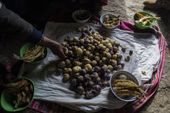
peru_titicaca_contamination_97207.jpg
In this Feb.3, 2017 photo, the Avila family sets their lunch of potatoes and fish on the floor of their home in Coata, a small village on the shore of Lake Titicaca, in the Puno region of Peru. Maruja Inquilla, a local environmental activist, has been visiting villagers to alert them of the dangers lurking in their food and water, in connection with contamination in the Lake Titicaca. (AP Photo/Rodrigo Abd)
aptopix_peru_titicaca_contamination_48409.jpg
In this Feb.3, 2017 photo, a sheep's carcass lays on the shore of Lake Titicaca, Peru. According to environmental activists, villagers' cattle and crops are dying due to contamination. (AP Photo/Rodrigo Abd)
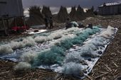
peru_titicaca_contamination_17717.jpg
In this Feb. 4, 2017 photo, Naty Lugano Quispe cleans fish nets in Kapi Cruz Grande, a village on the shore of Lake Titicaca, in the Puno region of Peru. A 2014 study suggested officials limit some fish consumption, but area inhabitants said they weren’t informed about the study or told they could be consuming fish containing mercury, cadmium, zinc and copper at levels higher than those advised for human consumption. (AP Photo/Rodrigo Abd)
peru_titicaca_contamination_98715.jpg
In this Feb. 4, 2017 photo, environmental activist Maruja Inquilla holds a dead bird called a "Choca," on the shore of Lake Titicaca, in Coata, in the Puno region of Peru. Untreated sewage water drains from two dozen nearby cities, and illegal gold mines high in the Andes dump up to 15 tons of mercury a year into a river leading to the lake. (AP Photo/Rodrigo Abd)
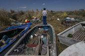
peru_titicaca_contamination_41876.jpg
In this Feb. 2, 2017 photo, a boy stands on a fishing boat on the littered shore of Lake Titicaca in Kapi Cruz Grande, in the Puno region of Peru. The camouflage-colored Titicaca water frogs that used to be in abundance have thinned in numbers and have been placed on a “critically endangered” list by the International Union for Conservation of Nature and just 10,000 remain. (AP Photo/Rodrigo Abd)
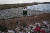
aptopix_peru_titicaca_contamination_45176.jpg
In this Feb. 4, 2017 photo, Melinda Quispe walks on the trash strewn shore of Lake Titicaca, as she holds her dog, in her village Kapi Cruz Grande, in the Puno region of Peru. The governments of Peru and Bolivia signed a pact in January to spend more than $500 million to attack the pollution problem of Lake Titicaca, though the details were vague. (AP Photo/Rodrigo Abd)

peru_titicaca_contamination_65012.jpg
In this Feb. 1, 2017 photo, children ride bikes along the Torococha River near a municipal waste treatment plant with water that flows into Lake Titicaca, in Juliaca, in the Puno region of Peru. Many of the more than 400,000 tourists who visit Lake Titicaca from Peru each year stop first in Juliaca, a town that produces 200 tons of trash daily, much of it winding up in a river that has turned into a conveyor belt of waste heading into the lake. (AP Photo/Rodrigo Abd)
peru_titicaca_contamination_09455.jpg
In this Feb. 1, 2017 photo, environmental activist Maruja Inquilla poses for a photo next to a Municipal waste treatment plant with water that flows into Lake Titicaca, in Juliaca, in the Puno region of Peru. "If the frogs could talk they would say, 'This is killing me,'" said Inquilla, who recently showed up at the Puno governor's house carrying plastic bags filled with hundreds of dead frogs in protest. (AP Photo/Rodrigo Abd)
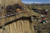
peru_titicaca_contamination_81718.jpg
In this Feb. 4, 2017 photo, trapped birds and caught trout lay out to dry on the thatched roof of a home in Kapi Cruz Grande, a village on the shore of Lake Titicaca in the Puno region of Peru. A government-sponsored study conducted in 2014 found mercury, cadmium, zinc and copper in four types of fish that form part of local population's diet at levels higher than those advised for human consumption. (AP Photo/Rodrigo Abd)
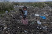
peru_titicaca_contamination_83839.jpg
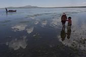
In this Feb. 2, 2017 photo, cousins from the Avila family search for discarded toys on the shores of Lake Titicaca, in Coata in the Puno region of Peru. The shores of South America's largest lake are littered with dead frogs, discarded paint buckets and bags of soggy trash. Less visible threats lurk in the water itself: highly toxic levels of lead and mercury. (AP Photo/Rodrigo Abd)
3_1_2017_ap-8947385177418201.jpg
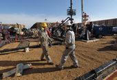
Hydraulic fracturing operations like this one near Mead, Colorado, have been blamed for a surge in earthquakes, but the U.S. Geological Survey says most of the shakes are not caused by fracking. (Associated Press)

3_1_2017_b4-harris8201.jpg
Illustration on the climate change debate by Alexander Hunter/The Washington Times

china_suing_for_better_air_29192.jpg
FILE - In this Jan. 5, 2017, file photo, Chinese men wearing masks to filter the pollution walk on a bridge near building shrouded by fog and pollution in Beijing. Yet the city’s average reading of the tiny particulate matter PM2.5 - considered a good gauge of air pollution - is still seven times what the World Health Organization considers safe. A group of Chinese lawyers is suing the governments of Beijing and its surrounding areas for not doing enough to get rid of the smog. (AP Photo/Andy Wong, File)

Trump.JPEG-070d3.jpg
A painting of former President Teddy Roosevelt is displayed above Environmental Protection Agency (EPA) Administrator Scott Pruitt, left, and first lady Melania Trump, right, as President Donald Trump speaks before signing the Waters of the United States (WOTUS) executive order in the Roosevelt Room in the White House, Tuesday, Feb. 28, 2017, in Washington, which directs the Environmental Protection Agency to withdraw the Waters of the United States (WOTUS) rule, which expands the number of waterways that are federally protected under the Clean Water Act. (AP Photo/Andrew Harnik)
oil_and_gas_health_risk_23119.jpg
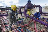
FILE - In this March 29, 2013 file photo, workers tend to a well head during a hydraulic fracturing operation outside Rifle, in western Colorado. Colorado health officials said Wednesday, March 1, 2017, that air monitoring and a dozen existing studies on air pollution from oil and gas sites indicate the risk of harmful effects on humans appears to be low, but they stressed that more study is needed. (AP Photo/Brennan Linsley, File)

bull_trout_lawsuit_12908.jpg
FILE - This undated file photo provided by the U.S. Forest Service shows a bull trout in the Little Lost River in Idaho. A federal lawsuit by an environmental group seeking to force federal agencies to analyze whether about two dozen dams operating in Idaho, Oregon, Washington and Montana are harming bull trout has been dismissed. (Bart Gamett/U.S. Forest Service via AP,File)
wine_grape_record_40918.jpg
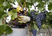
FIE--In this Sept. 16, 2014, file photo, Yolanda Gil harvests Merlot wine grapes at the Dineen Vineyards in Zillah, Wash. The state of Washington produced a record harvest of wine grapes in 2016. The Washington Wine Commission reported Wednesday that the 2016 harvest was 270,000 tons, up 22 percent from the previous year. (Gordon King/Yakima Herald-Republic via AP, file)
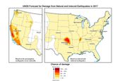
quake_forecast_57779.jpg
In this image provided by the U.S. Geological Survey, the USGS's 2107 earthquake forecast map. Federal scientists forecast that Oklahoma will continue to have the nation's biggest man-made earthquake problem but it probably won't be as shaky as recent years. In its annual national earthquake outlook, the USGS reported Wednesday, March 1, 2017, that a large portion of Oklahoma and parts of central California have the highest risk for a damaging quake this year: between 5 and 12 percent. The outlook is published in the journal Seismological Research Letters.(U.S. Geological Survey via AP)
quake_forecast_02774.jpg
FILE - In this Nov. 6, 2011 file photo, bricks that fell after two earthquakes are seen in Sparks, Okla, Federal scientists forecast that Oklahoma will continue to have the nation's biggest man-made earthquake problem but it probably won't be as shaky as recent years. In its annual national earthquake outlook, the U.S. Geological Survey reported Wednesday, March 1, 2017, that a large portion of Oklahoma and parts of central California have the highest risk for a damaging quake this year: between 5 and 12 percent. The outlook is published in the journal Seismological Research Letters. (AP Photo/Sue Ogrocki, File)