


Disaster_Accident
Latest Stories
15737040ee0e8a054b0f6a7067001cbe.jpg
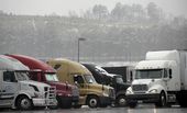
Tractor trailer rigs parked at a gas station are covered with snow about 40 miles north of metro Atlanta, in Emerson, Ga., on Tuesday, Feb. 11, 2014. President Obama signed an emergency declaration for Georgia as the winter storm hit the state Tuesday. (AP Photo/David Tulis)

68600a5cee1b8a054b0f6a7067004233.jpg
FILE - In this June 16, 2010, file photo, family and friends of crash victims of Continental Connection Flight 3407 in February 2009 near Buffalo, N.Y., listen to airline executives testify during a House subcommittee on aviation hearing on Capitol Hill in Washington. At a Wednesday, Feb. 12, 2014, memorial service on the anniversary of the crash of Continental Connection Flight 3407, the families plan to thank those who supported them — and vow to continue their fight to make air travel safer. (AP Photo/Haraz N. Ghanbari, File)

5621a7d6ee1a8a054b0f6a7067008820.jpg
FILE - In this Feb. 12, 2009, file photo, Continental Airlines Flight 3407 operated by Manassas, Va.-based Colgan Air, plane burns after it crashed into a house in Clarence Center, N.Y. At a Wednesday, Feb. 12, 2014, memorial service on the anniversary of the crash of Continental Connection Flight 3407, the families plan to thank those who supported them — and vow to continue their fight to make air travel safer. (AP Photo/David Duprey, File)
fa840ddbedcb89054b0f6a70670082a0.jpg
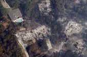
File - In this Sept. 7, 2011 file photo, homes destroyed by wildfire are seen near Bastrop, Texas. Forestry officials say this year's wildfire threat will be highest in only some parts of Texas but even that danger isn't close to what happened three years ago when blazes burned more than 2,700 homes and blackening about 6,200 square miles (AP Photo/Eric Gay, File)
f4993bd8edcb89054b0f6a7067007e9f.jpg
File - In this Sept. 7, 2011 file photo, a home destroyed by wildfire is seen among burned trees near Bastrop, Texas. Forestry officials say this year's wildfire threat will be highest in only some parts of Texas but even that danger isn't close to what happened three years ago when blazes burned more than 2,700 homes and blackening about 6,200 square miles (AP Photo/Eric Gay, File)
e7f7a021edcb89054b0f6a706700608b.jpg
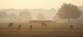
File - In this Sept. 7, 2011 file photo, smoke from a wildfire hangs over a field of cattle in Bastrop, Texas. Forestry officials say this year's wildfire threat will be highest in only some parts of Texas but even that danger isn't close to what happened three years ago when blazes burned more than 2,700 homes and blackening about 6,200 square miles (AP Photo/Eric Gay, File)
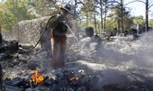
ee8fc590edcb89054b0f6a70670004fd.jpg
File - In this Sept. 8, 2011 file photo, a firefighter sprays a hot spot at a home destroyed by wildfires, in Bastrop, Texas. Forestry officials say this year's wildfire threat will be highest in only some parts of Texas but even that danger isn't close to what happened three years ago when blazes burned more than 2,700 homes and blackening about 6,200 square miles. (AP Photo/Eric Gay, File)