


Mackinac Bridge
Latest Stories

mackinac_pipeline_62622.jpg
FILE - In this May 31, 2002 file photo, the sun sets over the Mackinac Bridge and the Mackinac Straits as seen from Lake Huron. The bridge is the dividing line between Lake Michigan to the west and Lake Huron to the east. Michigan's attorney general, Republican Bill Schuette, called Thursday, June 29, 2017 for shutting down the nearly 5-mile-long (8-kilometer-long) section of Enbridge Inc.'s Line 5 under the Straits of Mackinac. (AP Photo/Al Goldis, File)
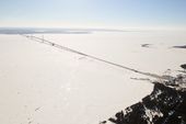
4b857a15575dc5064b0f6a706700b9fe.jpg
POOL PHOTO -- In this Feb. 11, 2014 aerial photo the Mackinac Bridge over the the Straits of Mackinac spans an ice cover that stretches into the horizon in Michigan. As of Feb. 13, the ice cover extended across 88 percent of the Great Lakes and almost completely covered, according to the federal government’s Great Lakes Environmental Research Laboratory in Ann Arbor. (AP Photo/ Traverse City Record-Eagle, Keith King Pool)